دوتنه:Mina de Chuquicamata, Calama, Chile, 2016-02-01, DD 110-112 PAN.JPG

اصلي دوتنه (۹٬۴۷۱ × ۴٬۷۲۰ پېکسل, د دوتنې کچه: ۱۹٫۸۷ مېگابايټ, MIME بڼه: image/jpeg)
لنډيز
| څرگندونه |
Español: Vista panorámica de Chuquicamata, una mina de cobre nacionalizada situada a 2,850m de altura sobre el nivel del mar en las cercanías de la ciudad de Calama, norte de Chile. Chuquicamata es la mayor mina de cobre abierta del mundo por volumen excavado y se comenzó en 1882 para extraer oro y cobre. Tiene 4,5 km de largo, 3,5 de ancho y 850 m de profundidad, lo que la convierte en la segunda mina abierta más profunda del mundo (después de la mina del cañón de Bingham en Utah, Estados Unidos).
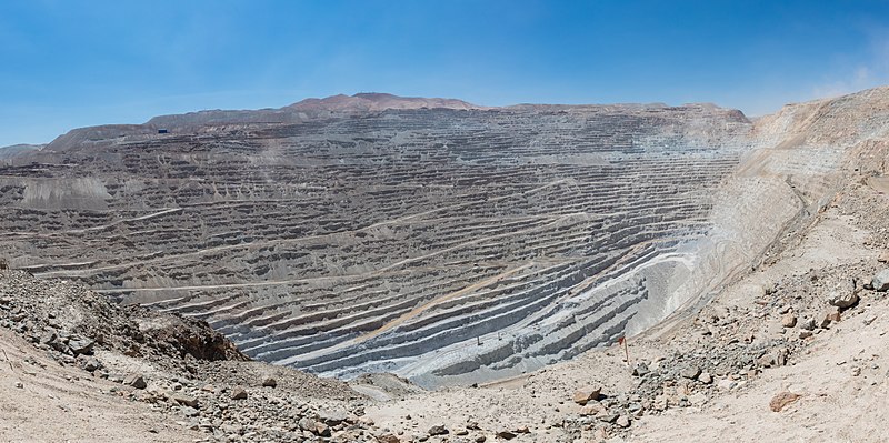
English: Panoramic view of Chuquicamata, a state-owned copper mine located at 2,850 metres (9,350 ft) above sea level just outside Calama, north of Chile. It is by excavated volume the largest open pit copper mine in the world. The huge hole was started in 1882 as a mine to extract gold and copper. It is 4.5 kilometres (2.8 mi) long, 3.5 kilometres (2.2 mi) wide and with a depth of 850 metres (2,790 ft) it is the second deepest open-pit mine in the world (after Bingham Canyon Mine in Utah, USA). Note: to get a feeling of the scale spot out a haul truck, which is 9.5 metres (31 ft) long and 4.5 metres (15 ft) high.
Polski: Panorama Chuquicamaty, państwowej kopalni rudy miedzi położonej na wysokości 2850 m n.p.m., na obrzeżach miasta Calama w północnym Chile. Pod względem odkrytej objętości jest to największa kopalnia odkrywkowa rudy miedzi na świecie. Kopanie olbrzymiej dziury rozpoczęto w 1882 roku jako kopalnię złota i miedzi. Ma ona 4,5 km długości, 3,5 km szerokości oraz 850 m głębokości i jest drugą co do głębokości kopalnią odkrywkową na świecie (po Bingham Canyon Mine w Utah, w USA).
Português: Vista panorâmica de Chuquicamata, uma mina de cobre nacionalizada situada a 2 850 metros de altitude nas proximidades da cidade de Calama, norte do Chile. Chuquicamata é a maior mina a céu aberto de cobre do mundo por volume escavado e sua exploração foi iniciada em 1882 com a extração de ouro e cobre. Tem 4,5 km de comprimento, 3,5 km de largura e 850 metros de profundidade, o que faz dela a segunda mina a céu aberto mais profunda do mundo (depois da mina de cobre Kennecott em Utah, Estados Unidos).
Čeština: Panoramatický pohled na povrchový důl Chuquicamata v oblasti Calama, severní Chile. Státem vlastněný důl na mědenou rudu je z hlediska vytěženého množství materiálu největší na světě. Leží ve výšce 2 850 m.n.m.. Je přibližně 4,5 km dlouhý, 3,5 km široký a 850 m hluboký. Těžba zlaté a měděné rudy zde započala již v roce 1882.
Македонски: Панорама на државниот рудник „Чукикамата“ кај Калама, северно Чиле. Ова е најголемиот површински коп за бакар во светот.
|
||||||||||||||||||||
| نېټه | |||||||||||||||||||||
| سرچينه | شخصي اثر | ||||||||||||||||||||
| ليکوال |
|
||||||||||||||||||||

Assessment
|
This image was selected as picture of the day on Wikimedia Commons for 25 September 2016. It was captioned as follows: English: Panoramic view of Chuquicamata, a state-owned copper mine located at 2,850 metres (9,350 ft) above sea level just outside Calama, north of Chile. It is by excavated volume the largest open pit copper mine in the world. The huge hole was started in 1882 as a mine to extract gold and copper. It is 4.5 kilometres (2.8 mi) long, 3.5 kilometres (2.2 mi) wide and with a depth of 850 metres (2,790 ft) it is the second deepest open-pit mine in the world (after Bingham Canyon Mine in Utah, USA). Other languages:
Čeština: Panoramatický pohled na povrchový důl Chuquicamata v oblasti Calama, severní Chile. Státem vlastněný důl na mědenou rudu je z hlediska vytěženého množství materiálu největší na světě. Leží ve výšce 2 850 m.n.m.. Je přibližně 4,5 km dlouhý, 3,5 km široký a 850 m hluboký. Těžba zlaté a měděné rudy zde započala již v roce 1882. English: Panoramic view of Chuquicamata, a state-owned copper mine located at 2,850 metres (9,350 ft) above sea level just outside Calama, north of Chile. It is by excavated volume the largest open pit copper mine in the world. The huge hole was started in 1882 as a mine to extract gold and copper. It is 4.5 kilometres (2.8 mi) long, 3.5 kilometres (2.2 mi) wide and with a depth of 850 metres (2,790 ft) it is the second deepest open-pit mine in the world (after Bingham Canyon Mine in Utah, USA). Español: Vista panorámica de Chuquicamata, una mina de cobre nacionalizada situada a 2,850m de altura sobre el nivel del mar en las cercanías de la ciudad de Calama, norte de Chile. Chuquicamata es la mayor mina de cobre abierta del mundo por volumen excavado y se comenzó en 1882 para extraer oro y cobre. Tiene 4,5 km de largo, 3,5 de ancho y 850 m de profundidad, lo que le hacen la convierte en la segunda mina abierta más profunda del mundo (después de la mina del cañón de Bingham en Utah, Estados Unidos). Polski: Panorama Chuquicamaty, państwowej kopalni rudy miedzi położonej na wysokości 2850 m n.p.m., na obrzeżach miasta Calama w północnym Chile. Pod względem odkrytej objętości jest to największa kopalnia odkrywkowa rudy miedzi na świecie. Kopanie olbrzymiej dziury rozpoczęto w 1882 roku jako kopalnię złota i miedzi. Ma ona 4,5 km długości, 3,5 km szerokości oraz 850 m głębokości i jest drugą co do głębokości kopalnią odkrywkową na świecie (po Bingham Canyon Mine w Utah, w USA). Português: Vista panorâmica de Chuquicamata, uma mina de cobre nacionalizada situada a 2 850 metros de altitude nas proximidades da cidade de Calama, norte do Chile. Chuquicamata é a maior mina a céu aberto de cobre do mundo por volume escavado e sua exploração foi iniciada em 1882 com a extração de ouro e cobre. Tem 4,5 km de comprimento, 3,5 km de largura e 850 metros de profundidade, o que faz dela a segunda mina a céu aberto mais profunda do mundo (depois da mina de cobre Kennecott em Utah, Estados Unidos). Македонски: Панорама на државниот рудник „Чукикамата“ кај Калама, северно Чиле. Ова е најголемиот површински коп за бакар во светот. |
This image has been assessed using the Quality image guidelines and is considered a Quality image.
|
منښتليک:
Another one of my pictures: Want to see more works of mine? click here |
Under this condition:
Please, use this work legally fulfilling the terms of the license! Please, let me know if you use this work outside Wikimedia Commons sending me an email on Furthermore, if you:
please, do not hesitate to contact me. |

|
Please do not overwrite the author's version with a modified image without discussing with the author. The author would like to make corrections only from the uncompressed RAW file. This ensures that changes are preserved and are based on the best possible source to achieve a high quality. If you think that changes are required, please, get in touch with the author. Otherwise, you can upload a new image with a different name without overwriting this one. Use {{Derived from}} or {{Extracted from}} for this purpose. |
- تاسې کولی شئ چې:
- بيا يې د نورو سره شريک کړئ – همدا اثر ولمېسئ، و وېشئ او بيا يې خپور کړئ
- بيا ادلون بدلون راولئ – بدل شوی اثر خپل کړئ
- د لاندې شرطونو له مخې:
- اړوندېدنه – تاسې بايد دا اثر د ليکوال يا منښتگر لخوا د ځانگړو شويو اصولو سره اړونده وگڼئ (خو په دې توگه نه چې داسې ښکاره شي چې گنې تاسې يا ستاسې لخوا کارېدنه د اثر د ملاتړ سبب شوی)
- يوشان شريکول – که تاسې همدا اثر بدلوئ، رغوئ، او يا يې هم سر له نوي جوړوئ نو په پايله کې رامېنځ ته شوی اثر به يوازې د همدې دوتنې ورته منښتليک پر بنسټ خپروئ.
د دوتنې پېښليک
په يوې نېټې/يوه وخت وټوکۍ چې د هماغه وخت او نېټې دوتنه چې څنگه ښکارېده هماغسې درښکاره شي.
| نېټه/وخت | بټنوک | ډډې | کارن | تبصره | |
|---|---|---|---|---|---|
| اوسنی | ۱۶:۲۷, ۲۰ مارچ ۲۰۱۶ | | ۹٬۴۷۱ × ۴٬۷۲۰ (۱۹٫۸۷ مېگابايټ) | Poco a poco | User created page with UploadWizard |
د دوتنې کارېدنه
داسې هېڅ کوم مخ نه شته چې د دغې دوتنې سره تړنې ولري.